

Linès Beach in Plouhinec - France
Information on the Linès Beach in Plouhinec (France)
Description and location of the Linès Beach in Plouhinec (56680)

Our opinion on the Linès Beach
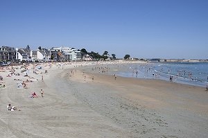
Plouhinec’s Linès Beach is the most westerly of the three and joins onto the Gâvres Peninsula. It is also the easiest to access (the others can be a little difficult to get to). To the west it is bordered by the main departmental road and a Military Zone used as a training ground by the French Navy (which is why parking is only allowed all week during summer, and throughout the rest of the year, only on weekends). If you decide to come off-season, take care, as sometimes shots ring out (although most of the training exercises are carried out with blanks it would be wise to look out for the signs before going off on an adventure!). Towards the east, the beach stretches for miles and onto Plouhinec’s other beaches.
Unfortunately this beach is not monitored.
To get here from Gâvres, follow the signs for Plouhinec on the D158 (the road borders the ocean and Gâvre’s small sea, allowing for spectacular views). After 5km (3 miles), you’ll reach the mainland where Linès Beach car park is.
Characteristics of the Linès Beach
Type of beach
- Creek
- Shade
- Lawn
- Pebbles
- Sand
- Cement
Equipment on the beach
- Handicap accessible
- Swimming pool
- Kids Club
- Shower
- Mattress rental
- Free parking
- Payed parking
- Paddle boats
- Lifeguards in season
- Restaurants
- WC
Recreation
- Beach volleyball
- Nautical Center
- Sand Yachting
- Nursery
- Fishing
- Nautical sports
- Surfing
- Scuba diving
- Kitesurfing
Location
- Difficult access
- Nude beach
- Wild beach
- Near city center
Miscellaneous
- Barbecues permitted
- Dogs allowed
- Smoke-free beach
Photos of the Linès Beach

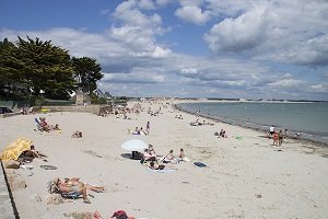
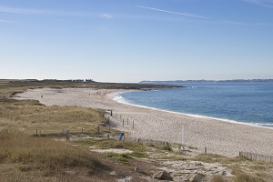
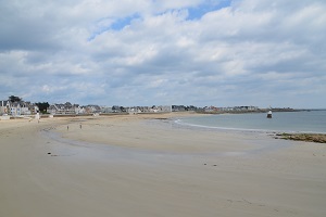
The vast sandy expanse of the first of Plouhinec’s beaches seen coming from Gâvres. The surrounding dunes count amongst some of the best in the region. Walking southwards you can reach Magouero Beach (which is monitored) by passing Kersine Beach.

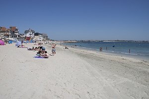
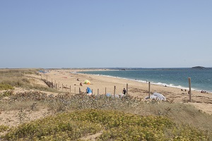
Walking along the north-west coast you can reach Gâvres. This beach is bordered by a Military Zone.

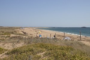
ESituated between Gâvres and Plouhinec, and running along the main departmental road, is the Plouhinec Firing Range (previously Gâvres Firing Range). This Military Zone is used as a training ground by the French Navy.

You can get to the beach using these stairs.

The main car park just off the main departmental road is open every day in July and August but only on weekends throughout the rest of the year.
Interactive map of the beaches of Plouhinec
Click on the beach of your choice:

All beaches at Plouhinec
Beaches near the Linès Beach:
Your opinion on the Linès Beach
Beautiful beaches nearby
Grande Plage - Gâvres
Main beach of Gâvres, Grande-Plage beach extends for several kilometres from ...
Toulhars Beach - Larmor-Plage
Toulhars Beach, as an extension of the beach of the city center, is one of ...
Port-Maria Beach - Larmor-Plage
Port Maria Beach in Larmor-Plage is the most central and busiest beach. This ...
Kerminihy Beach - Erdeven
Kerminihy Beach is one of the largest beaches of Erdeven. It extends for over ...
Seaside resorts in the area
Ploemeur
Situated in northern Brittany, close to Lorient, the town of Ploemeur offers a ...
Erdeven
Between Plouhinec and the peninsula of Quiberon, Erdeven offers 8 km of sandy ...
Island of Groix
The island of Groix is located in the south of Brittany, in the department of ...
Plouharnel
Located north of Quiberon Bay, (off the coast of Brittany) Plouharnel is, for ...
Tourist information
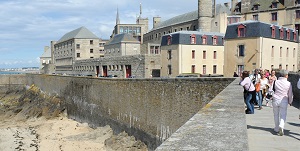
Saint-Malo, the Jewel of the Emerald Coast
Saint-Malo is the port city not to be missed during your visit to Brittany. On ...
Quiberon: A seaside destination in the south of Brittany
Connected to the mainland by a narrow stretch of sand over a few kilometres, the ...
Ploumanac'h in Brittany - Pure Pink granite rocks
In the heart of the Pink Granite Coast, situated between Trégastel and ...
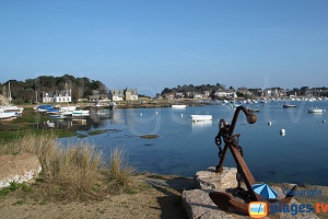
Gavres in the south of Brittany
The Morbihan is of remarkable natural beauty. The village of Gâvres is part of ...