

- Beach resorts in France
- Beaches in Provence-alpes-cote d'azur
- Beaches in Var
- Beaches in Saint-mandrier-sur-mer
Coudoulière Beach in Saint-Mandrier-sur-Mer - France
Information on the Coudoulière Beach in Saint-Mandrier-sur-Mer (France)
Description and location of the Coudoulière Beach in Saint-Mandrier-sur-Mer (83430)

Our opinion on the Coudoulière Beach
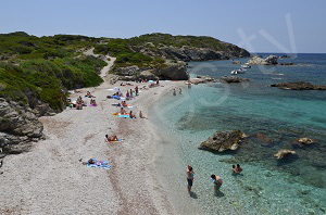
Coudoulière Beach in St Mandrier sur Mer is located to the southeast of the peninsula between the Batterie de la Renardière et Cap Cépet. This stone beach extends over about 200 meters along the coastal path. This beach has a lifeguard in July and August and there is a parking lot nearby.
Going toward the left we can join Cavalas Beach from the coastal path. It is an easy 800 meter walk that takes about 15 minutes. On the right we can join the Pointe de Marégau. The passage here is difficult, lasting about one hour for three kilometers. We also find Sainte-Asile Beach.
To get to this beach by car, follow directions for the “Centre d'instruction navale” (CIN – route du Cap Cépet). Then in the large curve, take the path on the right of the Coudoulière. A parking lot is at the end.
Characteristics of the Coudoulière Beach
Type of beach
- Creek
- Shade
- Lawn
- Pebbles
- Sand
- Cement
Equipment on the beach
- Handicap accessible
- Swimming pool
- Kids Club
- Shower
- Mattress rental
- Free parking
- Payed parking
- Paddle boats
- Lifeguards in season
- Restaurants
- WC
Recreation
- Beach volleyball
- Nautical Center
- Sand Yachting
- Nursery
- Fishing
- Nautical sports
- Surfing
- Scuba diving
- Kitesurfing
Location
- Difficult access
- Nude beach
- Wild beach
- Near city center
Miscellaneous
- Barbecues permitted
- Dogs allowed
- Smoke-free beach
Photos of the Coudoulière Beach

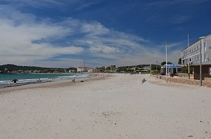
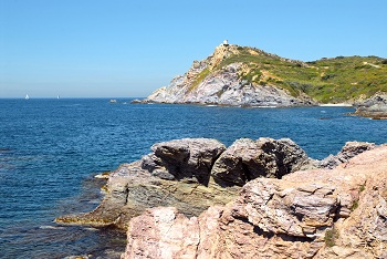
Here is a global view of the stone beach.

In the foreground is this stone beach in St Mandrier. On the left side we can see the seafront promenade that allows us to join the coastal path. In the background are the facilities of the Marine Nationale and the lighthouse of Cap Cépet. We can also see the Pointe du Roscas.

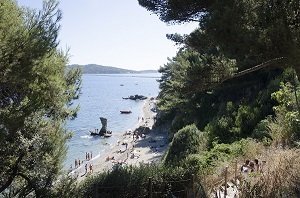
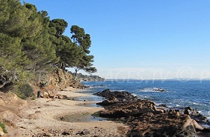
On the right is the coastal path that leads toward the harbor of Saint-Elme (some passages are difficult). Behind the hill is the Batterie de la Renardière (not visible in the photo). We can only see the edge of this beach. The stones are very large. At the end, we can make out the parking lot near this beach.
Interactive map of the beaches of Saint-Mandrier-sur-Mer
Click on the beach of your choice:

All beaches at Saint-Mandrier-sur-Mer
Beaches near the Coudoulière Beach:
Your opinion on the Coudoulière Beach
Monitored beaches nearby
Sablettes Beach - La Seyne-sur-Mer
Located downtown and at the entrance of the Saint-Mandrier peninsula, ...
Mitre Beach - Toulon
The beaches and creeks of Mitre in Toulon extend to the west of Fort ...
Fabregas Beach - La Seyne-sur-Mer
Fabregas Beach in La Seyne sur Mer is located to the south of the downtown ...
Verne Beach - La Seyne-sur-Mer
Verne Beach in La Seyne sur Mer is located near the Fabrégas bay. This beach ...
Seaside resorts in the area
Six Fours les Plages
The seaside resort of Six Fours les Plages is one of the largest towns in the ...
Ile des Embiez
Ile des Embiez is located in the Var department a few hundred meters from the ...
Carqueiranne
Carqueiranne is a small family-oriented seaside resort between Toulon and ...
Sanary sur Mer
Located on the Var coast between Bandol and Six-Fours-les-Plages, the seaside ...
Tourist information
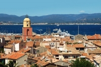
Saint-Tropez: beaches and luxury
One of the emblems of Saint-Tropez is the harbor with its yachts and events, ...
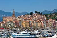
Holidays in Menton: beaches, Belle Époque houses and sun!
The famous seaside resort of Menton is a small town nestled in the heart of the ...
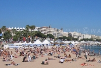
Cannes and the film festival: points of interest
Cannes, its festival... A destination which intrigues thousands of cinema-loving ...

Saintes Maries de la Mer : must-see destination in the Camargue region
Pilgrimage place and seaside resort, the city of Saintes-Maries-de-la-Mer, in ...